
How accurate are laser scanned floor plans, in three numbers
When people ask how accurate laser scanned floor plans are, they usually mean one number. There are three, and they are not the same. A laser scan floor plan starts with a point cloud, goes through drafting and ends as a DWG with dimensions and areas. Each step adds its own error. If you want the plans drawn for you, see our page on scan to CAD in Phoenix.
| Number | What it describes | Typical size |
|---|---|---|
| Scan accuracy | How close each measured point is to the real surface | ±2 to 6 mm at typical working ranges for our scans, depending on scanner, range and conditions |
| Drawing accuracy | How close the drawn lines are to the scanned surfaces | Looser than the scan; set by drafting rules you can specify |
| Area and definition | How walls, faces and areas are defined on the plan | Can outweigh both of the above on a large floor (worked example below) |
The USIBD Level of Accuracy (LOA) Specification, now at version 3.1, is the standard US way to write the first two into a contract. It separates the accuracy of the measured data from the accuracy of what is drawn or modeled on it, and version 3.1 adds a section on specifying tolerances with standard deviation.
Where floor plan error comes from
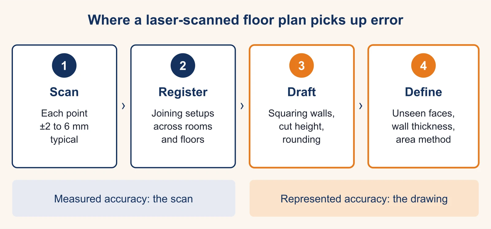
A laser scanned floor plan picks up error at four steps. The scanner is rarely the largest.
1. The scan itself
A terrestrial laser scanner measures distance and angle to each point. Accuracy depends on range, the surface (dark, shiny and glass surfaces return poorer data), the angle at which the beam hits it, and conditions on site. Close, matte, square-on surfaces measure best.
2. Registration
One setup sees one room. A building takes many setups, which are joined into one point cloud by registration. Small alignment errors between setups can add up along a chain of rooms, which is why a long corridor or a building scanned floor by floor through one stair needs care, and why good providers check registration before anyone drafts.
3. Drafting choices
A drafter turns points into lines. Three choices move the result:
- Squared or as-found: real walls bow and lean. Drawing them straight and square makes the plan easier to design on; drawing them as found keeps the deviation visible. Both are valid. Say which you want, and for squared walls, the deviation above which a wall is drawn as found (for example, 1/2 in, as an illustration).
- Cut height: a floor plan is a horizontal slice. Walls that lean, or tilt-up panels with a ledge, give different lines at different heights. Agree the cut height.
- Rounding: dimension strings are usually rounded, to the nearest 1/4 or 1/2 in, for example. The linework underneath can be more precise than the text.
4. Definitions
The scanner sees the inside face of an exterior wall from inside, and the outside face only if someone scans outside. Party walls between tenants are often seen from one side only. Where a face was never scanned, its position on the plan is an assumption, and it changes the gross area. Our guide to scan to BIM LOD covers the same issue for 3D models: what the scanner cannot see cannot carry a measured accuracy.
Tape measure vs laser scan floor plans
Tape measures are not inaccurate; they are short. NIST Handbook 44 (2026), Section 5.52 sets the tolerance a metal tape must meet: 1/16 in for intervals of 7 to 30 ft, 1/8 in for 31 to 55 ft, 3/16 in for 56 to 80 ft and 1/4 in for 81 to 100 ft. That is the tape alone, tested flat and under set tension. It does not include reading, hooking, sag or keeping the tape straight on a cluttered site, which add their own error.
| Method | How it measures | Strength | Weak point on a commercial floor |
|---|---|---|---|
| Tape measure | Contact, one distance at a time | Simple, cheap, fine for one room | Long walls need several pulls; every pull adds error |
| Hand-held laser meter | One laser shot at a time | Fast single distances, no sag | Plan is assembled shot by shot; angles and offsets are judged by eye |
| Phone or tablet LiDAR app | Short-range sensor plus camera, walking scan | Very fast for rooms and homes | Short range, makers' own accuracy claims; Apple publishes none for RoomPlan |
| Terrestrial laser scanner | Millions of points per setup, setups registered | Every wall in one coordinate system; ceiling heights and openings captured at once | Cost and processing time; only sees what is in line of sight |
| Total station | Precise single points from known positions | Survey control, critical points | Slow for full floor plans; used to anchor scans when a survey grid is required |
A percentage accuracy claim, common for phone apps, grows with distance. As an illustration, 1% of a 30 ft room is about 3.6 in; 1% of a 200 ft storefront run is 2 ft. A millimeter figure does not grow that way across a registered scan, which is why scanners are used for whole buildings.
Worked example: what the error does to square footage
Take a single-story floor of 100 × 200 ft, 20,000 sq ft, about the size of the two-dimensional CAD floor plan requests we are asked to quote in Phoenix. All numbers below are illustrative.
- Scan error. Suppose both overall dimensions are off by 6 mm (0.24 in, or 0.0197 ft), the top of our typical range. Added area ≈ 0.0197 × 100 + 0.0197 × 200 ≈ 6 sq ft, or 0.03% of the floor.
- Chained tape, tool tolerance only. A 25 ft tape takes 8 pulls along the 200 ft side and 4 along the 100 ft side. At the Handbook 44 tolerance of 1/16 in per pull, the worst case is 1/2 in (0.0417 ft) on the long side and 1/4 in (0.0208 ft) on the short side. Added area ≈ 0.0417 × 100 + 0.0208 × 200 ≈ 8 sq ft, before any reading or alignment error.
- Wall thickness assumed wrong. The exterior walls were scanned from inside only, and the drafter assumed a wall 2 in thinner than it is. Each overall dimension grows by 4 in (two walls), 0.333 ft. Added area ≈ 0.333 × 100 + 0.333 × 200 ≈ 100 sq ft, 0.5% of the floor.
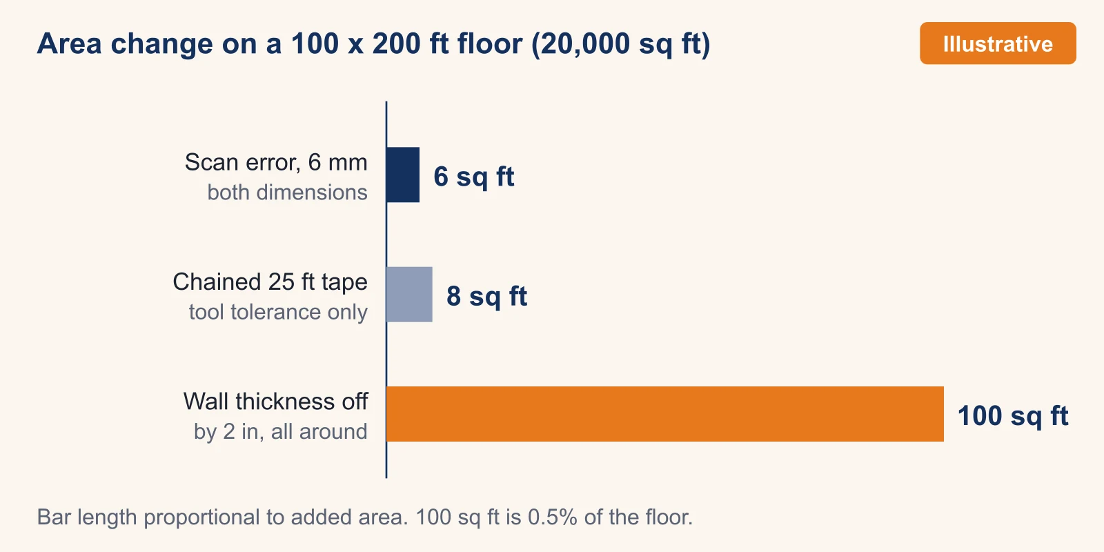
The lesson: on a large commercial floor, ask how unseen faces and wall thicknesses are handled before you ask about scanner specs. If gross area matters for a lease or a sale, scan the exterior too, and say which area standard the plan must follow, such as a BOMA method for rentable area.
What a laser scanned floor plan cannot show
- Anything inside walls, under slabs or above closed ceilings. Lift ceiling tiles or open panels before the scan if they matter.
- Rooms the scanner could not enter: locked suites, occupied spaces with no access, areas blocked by racking or stock.
- The far side of glass and mirrors without a setup on that side; both return poor data.
- Exterior faces and wall thickness, unless the outside was scanned too.
An honest plan marks these areas with a note instead of filling them with guesses.
How to check a floor plan you received
- Agree the check before the work. Put the method in the scope: which dimensions, measured how, against which tolerance. An accuracy figure without an agreed way to verify it ends in arguments, not answers.
- Measure between well-defined points. Use door jambs, column faces and corners you can hit exactly, not a long shot across a room to a wall you cannot see squarely. A single wall-to-wall shot combines the error of two surfaces and of your own aim.
- Check several dimensions in different areas. One reading proves little. Five or six spread across the floor show whether registration held.
- Compare with the point cloud, not only the drawing. If you received the registered cloud, overlay the plan on it in AutoCAD or Revit. Differences between the cloud and the lines are drafting; differences between the cloud and your tape are measurement.
- Read the notes. Squared or as-found, cut height, assumed wall thicknesses and unscanned areas should all be stated on the sheet or in the transmittal.
Laser scanned floor plans in Phoenix: what to specify
Much of the commercial stock in Phoenix and across Maricopa County is tilt-up concrete warehouses and strip retail from the 1970s and 80s, often altered by tenants without updated drawings. Tilt-up panels and long storefront runs are exactly where chained tape errors and squaring decisions show up. Requests we are asked to quote, such as as-built floor plans with ceiling heights, door and window sizes and photos for a City of Phoenix Certificate of Occupancy submittal, are typically sealed and submitted by the client's architect, with our drawings as the measured base. Our deliverables are non-certified; if you need certified measurements, use an Arizona-registered land surveyor.
To get plans you can trust, put these in the request: the sheets (floor plans, reflected ceiling plans, elevations); squared or as-found, with a threshold; cut height; how exterior and party walls are handled; the area standard if area matters; the LOA or tolerance for the drawing; file formats (DWG, PDF, the point cloud); and the deadline. Our page on scan to CAD in Phoenix lists turnaround and pricing, our guide to point cloud file formats covers the scan files, and you can send your floor plan request for a quote.
Frequently asked questions
How accurate are laser measurers?
A hand-held laser distance meter measures a single distance very precisely, and its makers publish an accuracy figure on the spec sheet. The weak point on a floor plan is not the meter but the method: each shot needs a clean target, and a plan built from hundreds of single shots chains their small errors together. A scanner measures every surface from each setup and ties the setups together.
What is 3D scanning technology?
A terrestrial 3D laser scanner sits on a tripod, sweeps a laser around the room and records the distance and direction to millions of points. Scans from several positions are registered into one point cloud, and drafters trace walls, doors and columns on that cloud to produce DWG floor plans.
Can AI measure floor plans?
Apps can draw floor plans automatically from a phone's LiDAR sensor and camera. Apple's RoomPlan, which many apps build on, outputs room models with dimensions, but Apple's page states no accuracy figure. Automated drawing saves drafting time; the accuracy still depends on the sensor and on someone checking the result.
What is the difference between LiDAR and laser scanning?
LiDAR is the measuring principle: timing laser light to get distances. A terrestrial laser scanner is one LiDAR instrument, set up on a tripod for building work. Phone sensors, drones and mobile mapping systems also use LiDAR, at different ranges and accuracies.
Are laser scanned floor plans accurate enough for a permit?
They are accurate enough to be the measured base. In the City of Phoenix, floor plans in a permit or Certificate of Occupancy package are typically prepared and submitted by your architect or design professional, who works from the scanned plans. Our plans are non-certified informational deliverables, not a licensed survey.
Is a laser scan more accurate than a tape measure?
Over a whole floor, usually yes, because a tape has to be chained across long walls and each pull adds error, while a registered scan measures every wall in one coordinate system. For one short room dimension, a careful tape reading and a scan will agree to a fraction of an inch.