
3D laser scanning in Phoenix: what you actually get
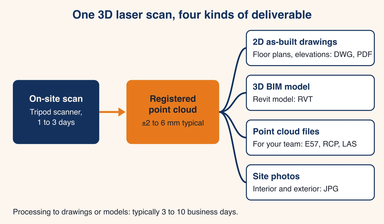
3D laser scanning measures a building with a laser instead of a tape. A scanner on a tripod sweeps the space from many positions and records millions of points, each with X, Y and Z coordinates. Joined together, those points form a point cloud: a measured 3D copy of the building that drafters turn into floor plans, elevations or a BIM model.
We are a Phoenix 3D scanning company working on commercial and industrial property across the Valley and Maricopa County. Our job is simple to describe: you need dimensions of a building that exists, we capture them once, completely, and give you the files your team works in. That might be a set of as-built floor plans for a tenant improvement in Midtown, a Revit model for a renovation in Old Town Scottsdale, or a registered point cloud of a warehouse near Sky Harbor that your engineer will work from directly.
If you want the long version of how the technology works, read our guide to what 3D laser scanning is and how it works. The rest of this page is about getting it done in Phoenix: services, what to send, timing, price, accuracy and local conditions.
The point cloud: the raw measured record
The first product of every scan is the registered point cloud. Registration means every scan position is aligned into one coordinate system, and noise (people walking through, reflections) is cleaned out. You can open it in Autodesk ReCap, Revit, AutoCAD or Navisworks and measure anything that was in view of the scanner, months after the site visit.
Drawings and models: what most Phoenix teams order
Most buyers do not want the point cloud alone. They want 2D drawings (floor plans, reflected ceiling plans, elevations, sections) in AutoCAD DWG and PDF, or a 3D Revit model. Both are drawn from the same point cloud, so you can order one now and the other later without a second site visit.
3D laser scanning services in Phoenix
Pick the service by the file you need at the end. The field work is similar for all of them; the processing and the deliverable change.
| You need | Service | Typical files |
|---|---|---|
| Floor plans, elevations or sections of an existing building | As-built drawings in Phoenix | DWG, PDF |
| 2D CAD linework traced from a point cloud | Scan to CAD in Phoenix | DWG, PDF |
| A 3D Revit model of existing conditions | Scan to BIM in Phoenix | RVT |
| Registered scan data for your own team | Point cloud services in Phoenix | E57, RCP/RCS, LAS |
| Large outdoor sites, structures, high or hard-to-reach areas | LiDAR scanning in Phoenix | E57, LAS, DWG |
| A whole commercial building documented for a project or a sale | Commercial building scanning in Phoenix | Point cloud plus drawings |
As-built drawings and floor plans
As-built drawings in Phoenix are what most of the quote requests we receive ask for: existing-conditions floor plans, often with elevations and sections, for a renovation, a lease, a permit package or a sale. They are drawn from the scan, so wall thicknesses, door openings and ceiling heights are measured, not assumed.
What an as-built floor plan set usually shows
Walls, doors and windows with sizes, room names, ceiling heights, columns, stairs, fixed casework and visible utilities. Rooftop units and exterior elevations can be added. Tell us what the drawings are for and we will match the content to that use rather than to a default package.
Not drawn unless you ask
Furniture, loose equipment, hidden services above a hard ceiling or inside walls (a scanner only measures what it can see), and property lines (a surveyor's job, see below).
Scan to CAD
Scan to CAD in Phoenix is the drafting step on its own: we turn a point cloud into clean 2D AutoCAD linework. It suits teams that think in DWG layers and want plans or elevations they can edit right away. Three of the five project types we were asked to quote recently wanted 2D CAD floor plans.
Layers, scale and standards
We draft to your layer and title block standard if you send it. Otherwise we use a plain, consistent layer scheme so your drafters can map it to theirs in minutes.
Scan to BIM
Scan to BIM in Phoenix produces a Revit model of existing conditions: walls, floors, roofs, doors, windows, structure and, when scoped, the visible MEP. Architects and design-build firms use it as the starting model for a renovation, and contractors use it for coordination in Navisworks.
Choosing the level of development
The level of development (LOD) sets how much is modeled and how precisely. Existing-conditions models are often scoped at LOD 200 or LOD 300 for architecture; heavier MEP detail costs more. Our guide to scan to BIM LOD explains the trade-off before you commit.
Point cloud services
Point cloud services in Phoenix are for teams that model in house and only need the measured data: registered, cleaned point clouds in E57, RCP/RCS or LAS. One request we were asked to quote was a high-density scan of part of an outdoor turf field with a 5 mm accuracy target, delivered as a registered E57.
LiDAR scanning for sites and structures
LiDAR scanning in Phoenix covers large sites, outdoor structures, canopies, tall spaces and places you cannot easily reach. LiDAR is the same laser ranging principle as building scanning, applied to bigger or rougher environments.
Commercial building scanning
Commercial building scanning in Phoenix is the full package for a property: every floor, the roof and the exterior captured in one mobilization, with drawings or models scoped to the project. It fits owners documenting a building before a sale, a repositioning or a phased renovation.
What to send for a 3D scanning quote in Phoenix
The fastest quotes are the ones where we do not have to ask follow-up questions. Send these six details and we can usually price the job in one reply:
- Address of the building or site (and suite numbers if only part of it).
- Approximate square footage and number of floors. Include the roof and exterior if you need them.
- Occupied or vacant, and any access limits: badge areas, hours, ceiling access, lifts.
- Deliverables: floor plans, elevations, sections, reflected ceiling plans, a Revit model, a point cloud, site photos.
- File formats: DWG, PDF, RVT, E57, RCP, LAS, JPG. Say so if you do not want hosted virtual-tour links.
- Deadline, and what the files are for (design, permit, lease, sale).
Existing drawings, even old or partial ones, help too. Send these details through the quote form or call (520) 800-5310. We typically respond within one business day with a fee and our earliest scan date.
Laser scanning jobs Phoenix teams ask us to quote
These are anonymized examples of real requests from 2025 and 2026, shown so you can compare your project. They are requests we were asked to quote, not completed case studies.
- An architecture firm: as-built floor plans, wall dimensions, ceiling heights, door and window sizes, visible utilities, rooftop units and photos for a City of Phoenix Certificate of Occupancy submittal on an occupied 3-building collision center of about 7,300 sq ft. Files in PDF, DWG and JPG.
- A design-build firm: a 3D BIM model of 5 to 6 buildings, about 50,000 sq ft in total, in Old Town Scottsdale.
- A property group: 2D CAD floor plans for about 20,000 sq ft in Phoenix.
- A sports performance company: a high-density scan of part of an outdoor turf field in Phoenix, 5 mm accuracy target, registered point cloud in E57.
- A commercial real estate advisor: 2D CAD floor plans of two adjacent 3-story office buildings in Scottsdale, about 390,000 sq ft.
Most of these asked for a fee and the earliest date, on a 1 to 2 week timeline. That is normal, and it is why we answer with both.
How a Phoenix laser scanning project runs
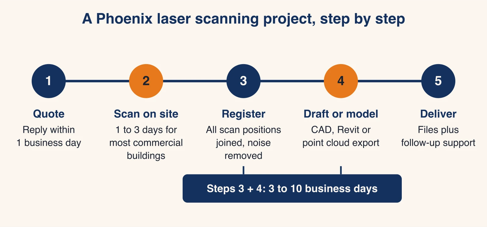
- Consultation and quote. We confirm the deliverables, formats, deadline and site access, then send a detailed quote.
- On-site scanning. A typical commercial building takes 1 to 3 days on site, depending on size and complexity.
- Registration. All scan positions are joined into one point cloud and cleaned of noise.
- Drafting or modeling. We produce the agreed CAD drawings, Revit model or point cloud exports. Processing typically takes 3 to 10 business days.
- Delivery and support. Files arrive digitally. Questions, extra extractions from the same scan and reasonable revisions are part of the follow-up.
Scanning occupied buildings
The scanner never touches anything, so offices, shops, clinics and warehouses usually stay open. People moving through a scan show up as noise and are removed during registration. When a space is too busy, after-hours or weekend scanning may be available at premium rates.
Worked example: a 20,000 sq ft office, floor plans only (illustrative)
This example uses our published ranges, not a real project. Say you send the six details on a Monday for a 20,000 sq ft, two-story occupied office in Phoenix and ask for floor plans in DWG and PDF.
The arithmetic
- Quote: within 1 business day, so by Tuesday.
- Scan: 1 to 3 days on site once scheduled; a building of this size and type usually sits at the short end.
- Processing: 3 to 10 business days after the scan.
- Total from scan day: roughly 4 to 13 business days to files, plus however long it takes to fit the scan into the calendar.
What would push it longer
Adding a Revit model, MEP detail or exterior elevations; limited access hours; or a change in scope after the scan. Each adds time on the processing side, rarely in the field.
What 3D laser scanning costs in Phoenix
Most commercial 3D laser scanning projects in Phoenix range from $2,500 to $15,000. Every job is priced as a project, with a detailed quote before any work begins.
| Factor | Effect on price |
|---|---|
| Size and complexity | More floors, more rooms and dense mechanical spaces need more scan positions and more drafting. |
| Deliverable type | Point cloud only costs least; 2D CAD drawings cost more; a Revit model costs the most. |
| Level of detail | Basic floor plans versus full elevations, sections and MEP changes processing time. |
| Access and safety | Lifts, roof access, escorts or safety programs add field time. |
| Travel | Projects outside the immediate Phoenix area may include travel time charges. |
| Timeline | Rush delivery and after-hours scanning may be available at premium rates. |
For a factor-by-factor breakdown with examples, read our 3D laser scanning cost guide. For your building, get a fixed quote for your project.
Accuracy, file formats and limits of our laser scans
Accuracy: ±2 to 6 mm, typical
Typical accuracy is ±2 to 6 mm at normal working ranges, depending on the scanner, the range to each surface and site conditions. Drawn deliverables are then as accurate as the drafting tolerance agreed in the scope.
Why accuracy is a range
Accuracy falls as distance from the scanner grows, and dark, shiny or glass surfaces return weaker signals. More scan positions and good overlap keep errors low. If your project needs a specific tolerance, put it in the quote request so we plan the scan around it.
File formats we deliver
| Format | What it is | Opens in |
|---|---|---|
| E57 | Vendor-neutral point cloud format, standardized as ASTM E2807 | Most point cloud and CAD software |
| RCP / RCS | Autodesk point cloud project and scan files | ReCap, Revit, AutoCAD, Navisworks |
| LAS | Standard LiDAR point format, common for sites | GIS and civil software |
| DWG | 2D CAD drawings | AutoCAD and most CAD tools |
| RVT | Revit BIM model | Autodesk Revit |
| PDF, JPG | Printable drawing sets, site photos | Anything |
Which format to ask for
Ask for the format your downstream team opens every day. If you are unsure, E57 plus DWG or RVT covers almost every workflow. Our guide to point cloud file formats compares E57, RCP and LAS.
What we do not provide
Non-certified deliverables. Our point clouds, drawings and models are informational. We are not licensed land surveyors, we do not provide engineering-certified measurements, and our files are not documents for legal validation. For a certified or boundary survey, hire an Arizona-registered land surveyor; we can refer you.
When you need a surveyor instead
Property lines, legal descriptions, ALTA surveys, flood elevation certificates and anything that must carry a surveyor's seal. A laser scan can sit next to that survey, but it does not replace it.
Laser scanning for City of Phoenix Certificate of Occupancy work
A common reason for an urgent as-built request in Phoenix is a Certificate of Occupancy (CO) on an existing building: a business moves into a space whose use or records do not match, and the City needs drawings. The City of Phoenix Planning and Development Department publishes the requirements in its Certificate of Occupancy Customer Packet (TRT 00340). Its eligibility questionnaire carries a $150.00 review fee and the City says it responds within 10 working days.
What the City's existing building checklist asks for
Floor layout drawing
At architectural scale (the City's example is ¼" = 1'-0"): the complete floor layout including equipment, the use of every room, and the dimensions of rooms, corridors and doors. That is exactly what a scan-based as-built floor plan captures, and it is where tape-measured sketches tend to fall short.
Site layout drawing
At engineering scale (the City's example is 1" = 20'): lot size and shape, property lines with dimensions, every building with distances to property lines, streets, alleys, easements and a north arrow.
The part a scan cannot settle
A scan can measure the building footprint, parking and distances between visible features. It cannot establish where a legal property line is. That comes from a recorded survey or plat, or from an Arizona-registered surveyor.
Who signs and submits
Your architect or design professional prepares, seals or submits the package. We provide the measured base they work from. We never claim the City accepts our drawings directly. Our guide on as-built plans for a Certificate of Occupancy in Phoenix walks through the process.
3D laser scanning in Phoenix heat and monsoon season
Phoenix weather changes how a scan is scheduled, mostly outdoors. The National Weather Service counted 70 days at or above 110°F at Sky Harbor in 2024 (preliminary data).
Roofs and exteriors in summer
Many terrestrial scanners have an upper operating limit around 40°C (104°F). For example, Leica's RTC360 datasheet lists +40°C as the top of its range. On a Phoenix roof in July that limit can be reached by mid-morning, so exterior and rooftop scans are planned for early morning. Air-conditioned interiors can be scanned at any hour.
What heat does to the data
Heat shimmer over hot roofs and asphalt can add noise to long-range points, and dark surfaces in direct sun get hot enough to matter for people and equipment. Short ranges and early starts keep both under control.
Monsoon dust and rain
Laser scanners measure what the beam hits first. Blowing dust and rain put false points in the air and wet surfaces return weaker signals. During monsoon season, roughly summer into early fall, we keep exterior work flexible and move it around storm days.
More detail is in our article on laser scanning in extreme heat.
Phoenix building types and the 3D scans they usually need
Tilt-up warehouses and industrial buildings
Concrete tilt-up warehouses line the I-10 and I-17 corridors, the area around Sky Harbor and Deer Valley. They are big, open and repetitive, so scanning is fast per square foot. Owners and tenants usually need a point cloud plus floor plans for racking, equipment layouts or a tenant improvement.
Typical deliverable
Registered point cloud (E57 or RCP) and a 2D floor plan with column grid, clear heights and dock doors.
1960s to 1980s strip retail and pad buildings
Older retail centers along Phoenix arterials have been remodeled many times, and the original drawings rarely match what is built. That is the classic case for as-built documentation before a new tenant moves in.
Typical deliverable
Suite floor plans with storefront elevations and roof plans showing rooftop units.
Mid-rise offices: Camelback Corridor, Midtown and Downtown
Multi-story offices along Camelback Road, Central Avenue and in Downtown Phoenix need repeatable floor plates for leasing, plus ceiling and MEP information for renovations. These are good candidates for a Revit model when a redesign is coming.
Typical deliverable
Floor plans per level and reflected ceiling plans, or a Revit model from the scan.
Mid-century homes: not our scope
Phoenix has many ranch homes from the 1950s to 1970s. We do not typically take residential work; our focus is commercial and industrial property.
Who uses 3D scanning services in Phoenix
Architects and designers
Existing-conditions plans and models before a renovation or change of use. See 3D laser scanning for architects.
Contractors and design-build firms
Pre-construction existing conditions, coordination and verification. See construction laser scanning in Phoenix.
Facility managers and property owners
Accurate floor plans for space planning, leasing and maintenance, and a point cloud that serves as a digital record of the building. See facility scanning in Phoenix.
Where we scan: Phoenix and the rest of Arizona
Our office is on North 24th Street in central Phoenix, so most of the city is a short drive: Downtown, Midtown, Arcadia, the Camelback Corridor, Ahwatukee, Deer Valley and the industrial areas west and south of Sky Harbor. We cover the Greater Phoenix metro and Maricopa County.
Scottsdale, Tempe, Mesa and Chandler
We work across the East Valley and north to Scottsdale on the same terms as Phoenix. City pages cover local specifics: 3D laser scanning in Scottsdale, 3D laser scanning in Tempe, 3D laser scanning in Mesa and 3D laser scanning in Chandler. We also scan in Glendale, Gilbert, Peoria, Surprise and Avondale.
3D laser scanning elsewhere in Arizona
Prescott, Flagstaff and Tucson are taken case by case, and projects outside the immediate Phoenix area may include travel time charges. Tell us the address and deadline and we will say quickly whether and when we can be there.
Frequently asked questions
How much does 3D laser scanning cost in Phoenix?
Most commercial 3D laser scanning projects in Phoenix range from $2,500 to $15,000. The price moves with building size and complexity, the deliverable (a point cloud costs less than CAD drawings, which cost less than a Revit model), level of detail, access, travel and deadline. We send a detailed, project-based quote before any work starts.
How long does a 3D laser scanning project take?
Scanning a typical commercial building takes 1 to 3 days on site, depending on size. Registration and drafting or modeling then take 3 to 10 business days. Rush delivery may be available at premium pricing; ask when you request a quote.
Can I use my phone as a LiDAR scanner instead?
Some phones and tablets have a small LiDAR sensor that is fine for a rough room sketch or a quick visual record. It is not built for measured drawings: range is short, drift builds up over large spaces, and the result is not registered to the standard of a tripod-mounted terrestrial laser scanner. For floor plans, elevations or a Revit model your team will design from, use a terrestrial scan.
What is the best 3D scanner for architecture?
For buildings, architects and contractors use terrestrial laser scanners: tripod-mounted units from makers such as Leica Geosystems, Trimble and FARO, set up at many positions and registered into one point cloud. Handheld SLAM scanners are faster but usually less accurate, and drone LiDAR suits roofs and large sites. The right choice depends on the accuracy and deliverable you need, which is why we scope the deliverable first.
Will the City of Phoenix accept your as-built drawings for a permit or Certificate of Occupancy?
Our drawings are the measured base, not the submittal. Floor plans used in a permit or Certificate of Occupancy package are typically prepared, sealed or submitted by your architect or design professional. We can format the floor plans to what the City's checklist asks for (room uses, dimensions of rooms, corridors and doors) so they can build the set quickly.
Are your laser scans certified surveys?
No. We provide non-certified informational deliverables: they are for design, planning and documentation, not for legal validation. We are not licensed land surveyors and do not provide engineering-certified measurements. If you need a boundary or certified survey, use an Arizona-registered land surveyor; we can refer you.
Do you scan homes?
Residential work is not our typical scope. We focus on commercial and industrial buildings, sites and facilities: offices, retail centers, warehouses, plants, restaurants and similar properties across the Phoenix metro.
Can you scan an occupied building or after hours?
Yes. Scanning is non-contact, so most offices, shops and shop floors keep working while we move around them. After-hours or weekend scanning may be available at premium rates when the space is too busy during the day.