
What is 3D laser scanning? It is a way to measure a building, site or object without touching it. A 3D laser scanner sends out laser light, records the distance and direction to every surface it hits, and stores each hit as a point in 3D space. A few minutes at one spot yields millions of points; several spots merged together give a complete, measured point cloud of the space. Firms that offer 3D laser scanning in Phoenix and elsewhere use that point cloud to draw floor plans, elevations and 3D models of existing conditions.
Short answer: 3D laser scanning = laser distance measurement repeated millions of times from a known position. Each return becomes an X, Y, Z point (often with color). The points form a point cloud with millimeter-level detail, typically ±2 to 6 mm on building work, which is then turned into CAD drawings, Revit models or measurements.
What is 3D laser scanning, in plain terms?
Think of a camera that records distance instead of color. A camera captures what a scene looks like; a laser scanner captures where every visible surface is. The output is not a picture but a set of coordinates. Many scanners also take photos and paint each point with the color seen there, so the point cloud looks almost like a photo you can walk through, yet every point can be measured.
The method has three defining traits:
- Non-contact. Nobody climbs to the ceiling with a tape. The scanner measures from the floor, the roof or across a street.
- Dense. It records everything in its line of sight, not just the dimensions someone thought to take. You can measure something months later without going back.
- Measured, not modeled. The point cloud is raw evidence of existing conditions. Drawings and models are built from it afterward.
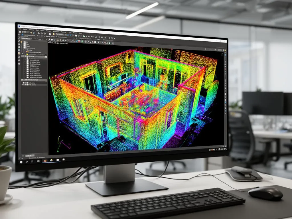
A point cloud is the core deliverable: a file of points, each with X, Y and Z coordinates and often a color and an intensity value. Common file formats are E57 (a vendor-neutral standard), RCP/RCS (Autodesk ReCap) and LAS.
How 3D laser scanning works
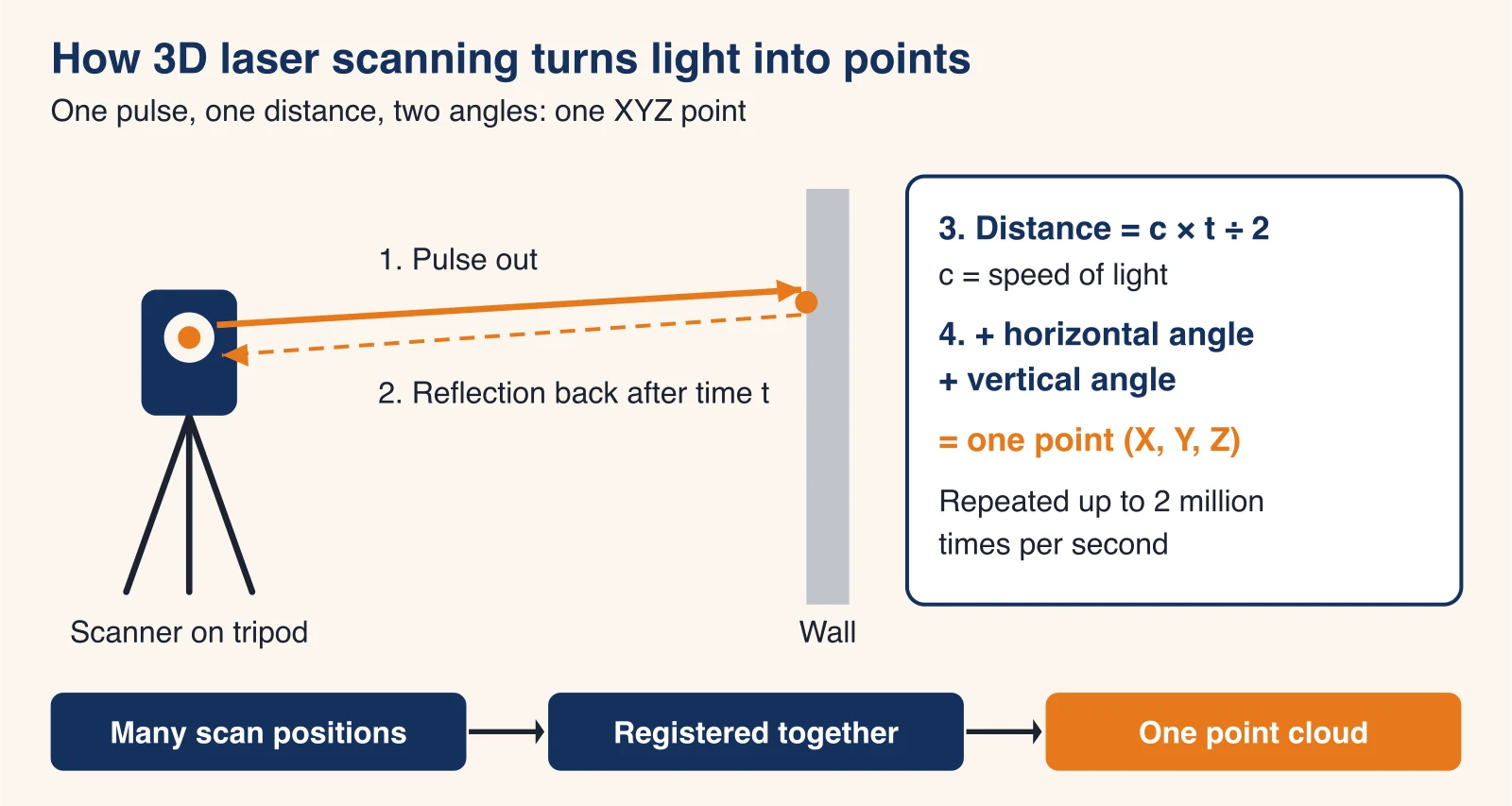
Every tripod scanner does the same basic thing. A laser fires, light reflects off a surface, a sensor catches the return, and the scanner calculates the distance. A spinning mirror sweeps the beam up and down while the head turns 360 degrees, so the beam visits nearly the whole sphere around the scanner. FARO's Focus i.1, for example, covers 300° vertically and 360° horizontally and measures up to 2 million points per second, according to its technical specification.
Time of flight: timing the pulse
A time-of-flight scanner times a short pulse on its round trip. Distance equals the speed of light multiplied by the round-trip time, divided by two (c·t/2). Light covers 1 mm in about 3.3 picoseconds, which shows how fine the timing has to be.
Worked example (illustrative arithmetic): a wall 10 m away means a 20 m round trip. At about 300,000 km per second, that takes roughly 67 nanoseconds. If the wall were 1 mm farther, the pulse would come back only about 6.7 picoseconds later (2 mm of extra path at 3.3 ps per mm). Scanners resolve that difference by averaging many returns and with careful electronics, which is why their accuracy is quoted in millimeters, not fractions of a millimeter.
Time of flight works at long range. Leica's 2025 scanner comparison chart lists more than 1 km of range for its ScanStation P50.
Phase shift: comparing waves
A phase-shift scanner sends a continuous beam whose brightness is modulated like a wave, and measures how far the returning wave has shifted. It is fast and precise at short to medium range, which suits interiors. Many current building scanners blend both ideas, so the label matters less than the published range and accuracy.
Triangulation: for objects, not buildings
Triangulation scanners shine a laser line on an object and watch it with a camera set at a known angle. They reach tens of micrometers but only over a few meters. That is the technology behind handheld scanners used for parts and reverse engineering. For rooms and buildings, time-of-flight and phase-shift scanners are the norm.
From scan positions to one point cloud
One position only sees what is in its line of sight. The operator moves the scanner through the building, room by room, outside around the facade, sometimes onto the roof, so that each position overlaps its neighbors. Back at the office, registration software aligns all positions into one coordinate system using shared geometry or targets, then the cloud is cleaned of noise, people and passing cars. This step is what turns a hundred separate scans into one measured building.
Types of 3D laser scanners
Scanners are grouped by how they move. Each trades accuracy against coverage speed.
| Type | How it moves | Typical use | Trade-off |
|---|---|---|---|
| Terrestrial (tripod) | Static, set up at a series of positions | Buildings, plants, facades, as-built drawings, scan to BIM | Highest accuracy per point; slower to cover large areas |
| Handheld / backpack (SLAM) | Walked through the space, position computed on the move | Quick interior capture, tight spaces | Fast, but accuracy drifts with distance walked |
| Mobile (vehicle) | Mounted on a car or rail cart with GNSS and an IMU | Roads, corridors, rail | Covers miles per hour; centimeter-level, not millimeter |
| Aerial (drone or aircraft) | Flown over the site | Terrain, large sites, vegetation, elevation models | Huge coverage; sees roofs, not interiors |
| Triangulation (handheld or arm) | Held close to an object | Parts, molds, reverse engineering | Sub-millimeter, but only a few meters of range |
For existing commercial buildings, the tripod-based terrestrial laser scanner is the standard tool. Leica, FARO and Trimble are among the best-known makers. Airborne and vehicle systems are usually called LiDAR; our guide to LiDAR vs 3D laser scanning explains where the terms overlap and where they don't.
How accurate is 3D laser scanning?
Manufacturers publish accuracy at stated distances, and it always grows with range. The figures below are copied from the makers' own spec sheets.
| Scanner (manufacturer spec) | Max range | Speed | 3D point accuracy |
|---|---|---|---|
| FARO Focus i.1 | 200 m (white, 90% reflectivity) | Up to 2 million pts/s | 2 mm @ 10 m; 3.5 mm @ 25 m |
| Leica RTC360 | 130 m | 2 million pts/s | 6.4 mm @ 50 m; 12.5 mm @ 100 m |
| Leica ScanStation P40 | 270 m | 1 million pts/s | 3.2 mm @ 50 m; 5.9 mm @ 100 m |
| Leica BLK360 | 45 m | 680,000 pts/s | 4 mm @ 10 m; 8 mm @ 20 m |
Sources: FARO Focus i.1 tech sheet; Leica TLS comparison chart, 2025. Listed to show the range of published figures, not as the equipment of any particular firm.
On real buildings, several things move the result away from the spec sheet:
- Range. Points 40 m away are noisier and sparser than points 8 m away. Good scan plans keep critical surfaces close.
- Surface. Glass, mirrors, polished stainless and very dark materials return weak or bounced signals.
- Registration. Small errors between positions add up across a long building unless the network is well tied together.
- Heat and stability. Sun on one side of a tripod makes it expand unevenly and slowly tilt the scan, a drift noted in the Wikipedia overview. In Phoenix this is a summer issue; our post on laser scanning in extreme heat covers scanner temperature limits and scheduling.
For floor plans, CAD and Revit work on commercial buildings, a realistic target is ±2 to 6 mm at typical working ranges. Ask any provider to state the tolerance in writing for your deliverable, not only the scanner's best-case figure.
3D laser scanning vs total station vs tape measure
Laser scanning replaces neither of the older tools entirely. Each wins at a different job.
| Tape and laser distance meter | Total station | 3D laser scanner | |
|---|---|---|---|
| What it records | One distance at a time | Single chosen points with very precise angles and distances | Millions of points, everything in view |
| Best for | A small room, a quick check | Control points, layout, legal survey work | Whole buildings, complex MEP, facades, anything you may need later |
| Missed dimensions | Common, means a site revisit | Only what was shot | Rare, measure later from the cloud |
| Typical output | Sketch with numbers | Coordinate list, survey drawing | Point cloud, then CAD drawings or a BIM model |
On larger jobs the two instruments work together: a total station sets precise control points, and the scans are tied to them so the whole cloud sits in one accurate coordinate system.
What you get from a 3D laser scan
Most buyers do not want the point cloud itself; they want what can be drawn from it. A scan of an existing building typically feeds:
- Point cloud files (E57, RCP/RCS, LAS) for designers who model themselves in Autodesk ReCap, Revit, AutoCAD or Navisworks.
- 2D CAD drawings (DWG and PDF): floor plans, reflected ceiling plans, elevations and sections.
- 3D BIM models in Revit (RVT), modeled to an agreed level of detail.
- Measurements and checks: clear heights, floor flatness, column grids, equipment clearances.
- Photo sets from the scanner's camera or a separate camera.
What 3D laser scanning is used for
The common thread is a decision that depends on existing conditions. Typical uses in commercial buildings:
- Renovation and tenant improvement design. Architects need accurate walls, openings, ceiling heights and structure before they draw anything new.
- Permit and occupancy packages. Owners often need current floor plans for a change of use or a Certificate of Occupancy; the architect seals and submits the set, using the measured drawings as the base.
- MEP retrofits and equipment installs. Routing new duct, pipe or conveyor through a crowded ceiling without clashes.
- Construction verification. Checking that slabs, steel or embeds match the design before the next trade builds on them.
- Facility management. A dated, complete record of a building for space planning and maintenance.
- Outside buildings: plants and refineries, heritage sites, accident and crime scene documentation, and reverse engineering of parts.
Benefits and limits of 3D laser scanning
Benefits
- Speed on site. A typical commercial building is captured in 1 to 3 days, often while it stays open.
- Completeness. One visit captures everything in view, which cuts return trips.
- Safety. High ceilings, roofs and live plant areas are measured from a distance.
- One shared truth. Architect, engineer and contractor work from the same measured data.
Limits
- Line of sight only. A scanner never sees inside walls, under slabs or above a hard-lid ceiling without an access panel. Racking full of product hides the wall behind it.
- Difficult surfaces. Glass, mirrors and polished metal produce gaps or ghost points that must be cleaned.
- Moving things. People, forklifts and traffic leave streaks that need extra positions or cleanup.
- Data size and processing. Registered clouds run to many gigabytes, and drafting takes days, not hours.
- Not a legal survey. Scan-based drawings are measurements for design and documentation.
Scan is not survey. Documentation firms, including Sonoran 3D Scanning, deliver non-certified, informational drawings and point clouds. Boundary, topographic or other certified surveys in Arizona come from an Arizona-registered land surveyor, and permit drawings are sealed by your architect or design professional.
Is 3D laser scanning the same as LiDAR?
Both rely on the same physics. NOAA defines lidar (light detection and ranging) as a remote sensing method that uses laser light, most often from aircraft, to map the Earth's surface. In building work, "3D laser scanning" usually means tripod scanners measuring to the millimeter, and "LiDAR" usually means airborne, drone or vehicle systems covering large areas at centimeter level. Many firms use the words interchangeably, so ask what platform and accuracy you are actually buying.
Getting a building scanned
If you are weighing a scan for a renovation, permit set or facility record, start by writing down what you need drawn, at what detail, in which file format, and by when. Those four answers drive scope and price far more than square footage. Ask any provider to confirm those four points in writing before work starts. For a project in the Valley, see how 3D laser scanning in Phoenix works with Sonoran 3D Scanning, or send your project details for a quote: address, square footage, occupied or vacant, deliverables, formats and deadline.
Frequently asked questions
What is a 3D laser scanner used for?
A 3D laser scanner measures existing buildings, sites and equipment so people can design against real conditions. Common uses are as-built floor plans, elevations and sections, Revit models for renovation, clash checks before new ducts or racking go in, floor flatness checks and a dated record of a facility.
How accurate is 3D laser scanning?
Published specs for tripod scanners are in the millimeter range and grow with distance: FARO lists 2 mm at 10 m for its Focus i.1, and Leica lists 6.4 mm at 50 m for the RTC360. For building documentation, a typical result is ±2 to 6 mm at normal working ranges, depending on the scanner, range, surface and registration.
How long does a 3D laser scan take?
One scan position takes from about 20 seconds to a few minutes, depending on the scanner and resolution. A typical commercial building takes 1 to 3 days on site, then 3 to 10 business days of processing to produce drawings or models.
What is the typical cost of a 3D laser scan?
It depends on size, detail, deliverables, access and schedule. In the Phoenix area, most commercial scanning projects range from $2,500 to $15,000. A raw point cloud costs less than the same scan drafted into CAD drawings or a Revit model.
What are the disadvantages of 3D laser scanning?
A scanner only measures what it can see, so walls, slabs and closed ceilings stay hidden. Glass, mirrors, polished metal and very dark surfaces return weak or false points. Files are large, processing takes time, and the result is a measured record, not a licensed survey.
Is 3D laser scanning the same as LiDAR?
They use the same principle: timing laser light to measure distance. In practice, LiDAR usually means scanners on aircraft, drones or vehicles mapping large areas, while 3D laser scanning usually means tripod scanners measuring buildings to the millimeter.
Is a laser scan a survey?
A laser scan is a measurement, not a legal survey. Scan-based drawings from a documentation firm are typically non-certified and informational. Boundary, topographic or other certified surveys in Arizona come from an Arizona-registered land surveyor.