
LiDAR scanning services in Phoenix: what we capture
We provide LiDAR scanning in Phoenix for the jobs that are too big, too high or too exposed to measure by hand: building exteriors and facades, parking structures, industrial yards, canopies, sports surfaces and other outdoor structures. Our capture is terrestrial LiDAR: a laser scanner on a tripod, moved from position to position. It is one of the services listed on our 3D scanning services page, and the field method is the same one we use inside buildings.
Searching "Phoenix LiDAR" also returns a drone LiDAR hardware maker with that name. We are not that company and do not sell equipment. We are a scanning service: we come to your site, scan it and hand you files.
What terrestrial LiDAR scanning is
LiDAR (light detection and ranging) measures distance by timing laser pulses that bounce back from surfaces. A terrestrial laser scanner spins on a tripod and records millions of these measurements around it, each one a point with X, Y and Z coordinates, often colored from the scanner's camera. One position sees only what is in its line of sight, so we scan from many positions and join them into a single point cloud. If you are wondering whether "LiDAR" and "3D laser scanning" are different services, our guide to LiDAR vs 3D laser scanning explains why they are mostly two names for the same measurement.
Where tripod LiDAR scanning works best
Terrestrial scanning is strongest where you need millimeter-level geometry of vertical and complex surfaces, measured from the ground. These are the outdoor jobs it suits.
Building exteriors and facades
Elevations, parapet heights, window openings, canopies and storefronts on tilt-up warehouses, strip retail and mid-rise offices. A facade scan gives your architect true elevations instead of a guess from old drawings. For whole-building work inside and out, see our building scanning in Phoenix page.
Parking structures
Deck levels, slopes, column grids, ramps, clearances and drainage low points. Repeated bays and long sight lines suit the scanner, but parked cars block the view, so we plan the scan for low-occupancy hours.
Industrial yards and outdoor equipment
Tanks, pipe racks, loading docks, trailers, pads and fences. The scan records what is actually there, including equipment that was added without drawings.
High or hard-to-reach areas
Rooftop units, high-bay ceilings, canopies, signs and structure you cannot safely tape. The scanner measures them from the ground or from a safe roof position, without a lift on every point.
Sports and recreation surfaces
One request we were asked to quote was a high-density scan of part of an outdoor turf field in Phoenix, with a 5 mm accuracy target and a registered point cloud in E57. Flatness, slopes and edges of a surface like that are exactly what dense ground-based scanning captures well.
Terrestrial LiDAR vs drone LiDAR, mobile SLAM and photogrammetry
LiDAR scanning is not one tool. The same laser principle is carried on a tripod, a drone, a backpack or a vehicle, and photogrammetry builds 3D from photos instead. Each one trades accuracy, coverage and speed differently. We only do the first row of this table; the others are here so you can pick the right one, even when it is not us.
| Method | Best at | Weak at | Typical fit in Phoenix |
|---|---|---|---|
| Terrestrial (tripod) LiDAR | Millimeter-level geometry of walls, structure, equipment and surfaces seen from the ground | Roofs and ground hidden from every position; open acreage takes many setups | Facades, parking structures, yards, canopies, interiors |
| Drone (aerial) LiDAR | Large open ground, terrain under sparse vegetation, roof tops, corridors | Vertical faces, under canopies, interiors; flights near airports need FAA authorization | Topography of land for development, long corridors |
| Mobile or SLAM LiDAR (backpack, handheld, vehicle) | Speed over long routes and big floor areas | Accuracy drifts over distance unless tied to control; noisier data | Quick coverage where centimeters are acceptable |
| Photogrammetry | Photo-real textures, roof surfaces from a drone, low cost visuals | Plain, dark or shiny surfaces; accuracy depends on photo overlap and control | Marketing visuals, roof condition, rough massing |
When tripod LiDAR is the right tool
Choose terrestrial scanning when the deliverable needs dimensions you will design or fabricate from: elevations, clearances, structural members, equipment positions, slab and deck levels. It is also the right choice when part of the job is indoors, because a drone cannot follow the scan inside.
When another method fits better
Drone LiDAR for open acreage and topography
If you need ground contours across many acres of open desert, a drone covers it in a fraction of the setups. Commercial drone flights run under the FAA's Part 107 rules for commercial operators, and much of central Phoenix sits in controlled airspace around Sky Harbor. We do not fly drones. For sealed topography, hire an Arizona-registered land surveyor.
Mobile and SLAM scanners for speed over long routes
SLAM (simultaneous localization and mapping) scanners are carried or driven and build the cloud as they move. They are fast, but their error grows along the route unless it is checked against fixed points. Our capture is tripod-based; if your tolerance allows a few centimeters and speed matters more, tell us during scoping and we will say plainly whether tripod scanning is worth the extra field time for your job.
Photogrammetry for visuals and roof surfaces
Photogrammetry rebuilds 3D from overlapping photos. It looks great and is cheap to capture, but blank stucco, dark asphalt and glass give it little to match, so dimensions are less reliable than a laser scan.
LiDAR scanning accuracy: what ±2 to 6 mm means on a site
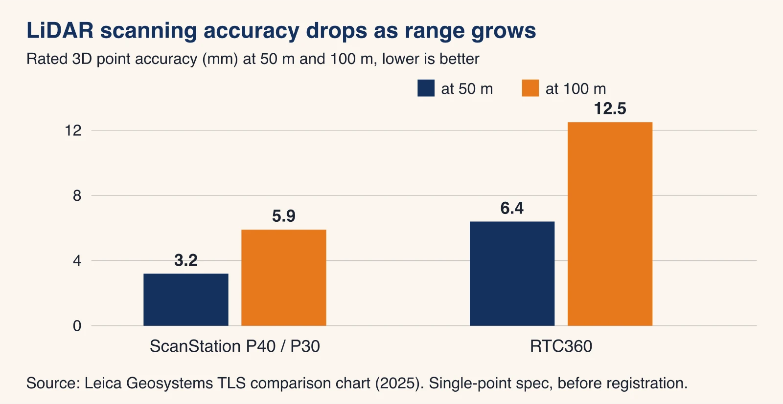
Our typical accuracy is ±2 to 6 mm at typical working ranges, depending on the scanner, the range and the conditions. On a large outdoor site, range is the variable that matters most, because a scanner's error grows the farther the surface is from it.
Accuracy falls with range
Manufacturers publish this directly. In Leica Geosystems' terrestrial laser scanner comparison chart, the compact RTC360 is rated at 6.4 mm 3D accuracy at 50 m and 12.5 mm at 100 m, while the long-range ScanStation P40 and P30 are rated at 3.2 mm at 50 m and 5.9 mm at 100 m. So a tall facade or a wide yard scanned from too few positions loses accuracy at the far edge. We hold accuracy by keeping positions closer together, not by trusting the maximum range on the spec sheet.
Registration and control
Targets and cloud-to-cloud registration
Registration joins all scan positions into one point cloud. It uses shared targets (checkerboards or spheres seen from two or more positions) or overlapping geometry between scans. Open sites have less geometry to lock onto than a building interior, so outdoors we rely more on targets and on generous overlap.
Local coordinates or your project coordinates
By default the point cloud is in a local coordinate system. If your civil engineer or surveyor has set control points, we can tie the scan to them so the data lands in your project coordinates. The control and its certification stay with your surveyor.
What LiDAR cannot see
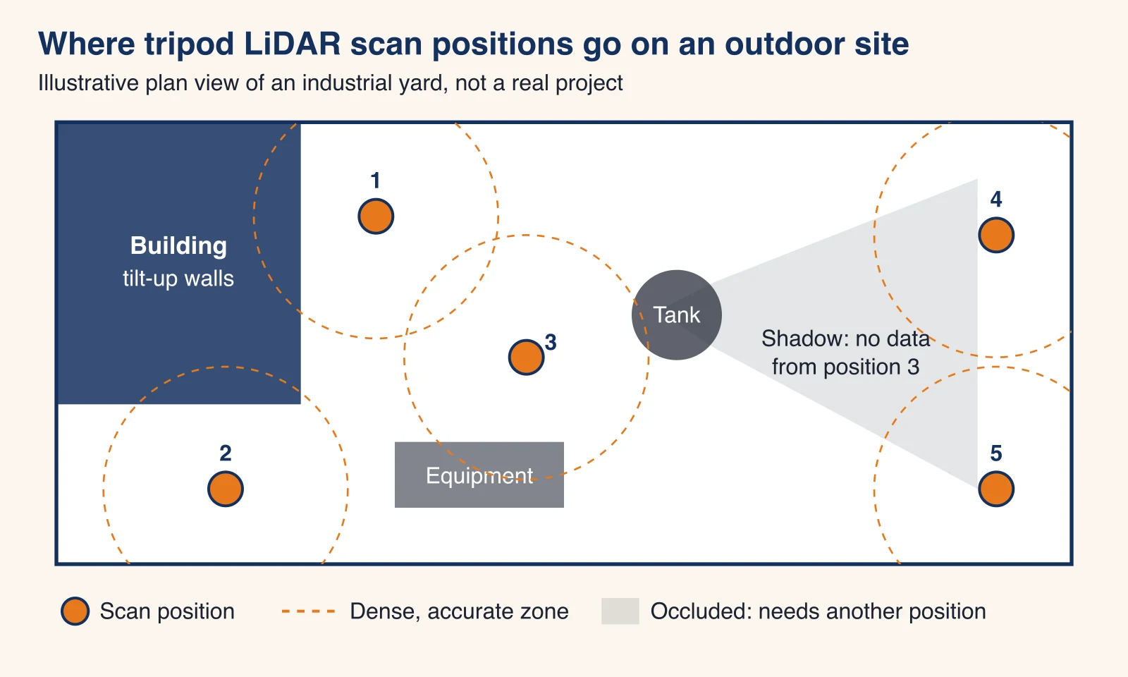
The laser needs a straight line to a surface. It does not see through walls, soil or slabs, and it leaves a shadow behind every tank, truck or column. Glass and water return little or no data, and very dark or glossy surfaces can be noisy. We plan extra positions for shadows and tell you in advance what a scan will not show.
LiDAR scanning outdoors in Phoenix: heat, glare and monsoon dust
Outdoor laser scanning in the Phoenix area has conditions most national pages skip. Our longer guide to laser scanning in extreme heat covers them in detail; here is what affects your project.
Heat: scanner limits vs a Phoenix July
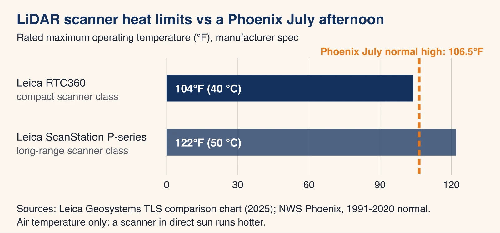
Laser scanners have rated operating temperatures. In the same Leica chart, the RTC360 is rated from -5 °C to +40 °C (104°F) and the ScanStation P-series from -20 °C to +50 °C (122°F). The NWS Phoenix office lists the 1991-2020 normal July average high at 106.5°F. An afternoon exterior scan in July can therefore run above the rating of common compact scanners, before counting sun on a dark scanner body or radiant heat off asphalt. Some competitor pages claim compact scanners are rated well above 120°F; the manufacturer's own chart says otherwise.
How we schedule summer exterior scans
From late spring to early fall, we book exterior LiDAR scanning for the early morning, keep the scanner shaded between positions and move interior work into the afternoon. Heat also moves the site itself: long steel members and roofing expand through the day, so for tight tolerances we scan comparable elements at a similar time of day.
Sun glare, reflective and dark surfaces
Strong sun washes out scanner photos used to color the point cloud and makes reflective metal panels, glazing and wet surfaces noisier. Low sun angles also put long shadows into the colored data. Early-morning scanning helps here too, and we can deliver an uncolored (intensity) cloud where color adds nothing.
Monsoon dust and rain
The NWS defines the Arizona monsoon season as June 15 to September 30. Blowing dust shows up as floating noise in a point cloud, and rain on the scanner or on the surfaces degrades the data. We watch the forecast, move the day when a dust storm or storm cell is expected, and remove residual noise during processing.
LiDAR scanning deliverables and file formats
The field scan is the same whatever you order; the deliverable decides the processing time. Say which software will open the files and we export to suit it.
| Deliverable | Formats | Opens in | Good for |
|---|---|---|---|
| Registered point cloud | E57, RCP/RCS, LAS | Autodesk ReCap, Revit, AutoCAD, Navisworks, most point cloud tools | Your own team measuring, modeling or checking design |
| 2D drawings | DWG, PDF | AutoCAD and most CAD software | Site plans of structures, elevations, sections |
| 3D model | RVT | Revit | Design and coordination on existing structures |
| Photos | JPG | Any viewer | Context for the drawings |
Point clouds from LiDAR scans: E57, RCP/RCS and LAS
E57 is the vendor-neutral exchange format, RCP/RCS is Autodesk's project format for ReCap, Revit and AutoCAD, and LAS is the common format for GIS and civil software. Our point cloud services in Phoenix page covers registration reports, file sizes and decimation if you only want the data.
Drawings and models from LiDAR data
Site plans and elevations
We draw what the scan sees: building outlines, structures, equipment footprints, curbs, pads, columns and elevations of the faces you name.
Drawn by default
Visible structure and openings, heights and levels of the elements in scope, and dimensions to the faces we scanned.
Left out unless you ask
Underground utilities, property lines, ground contours across open land and anything not in line of sight. Those belong to a surveyor or a utility locator.
Revit models of structures
For design work on an existing structure, we model it in Revit from the point cloud. Our scan to BIM service explains levels of detail and what gets modeled.
Site photos
Interior and exterior photos are available on request and arrive as a JPG set, which helps anyone reading the drawings who has not walked the site.
Turnaround for LiDAR scanning in the Phoenix area
We typically reply to a quote request within one business day. Most commercial scanning takes 1 to 3 days on site, and processing typically takes 3 to 10 business days depending on the deliverable. Rush delivery may be available at premium pricing, and after-hours or weekend scanning may be available at premium rates for operating sites.
- Consultation and quote. Site, scope, deliverable, accuracy, access and deadline, then a detailed quote.
- On-site scanning. Tripod positions planned around obstructions and range; most commercial scanning takes 1 to 3 days.
- Registration and cleanup. All positions joined into one point cloud, checked, and cleared of vehicles, people and dust.
- Deliverables. Exports, drawings or models in 3 to 10 business days.
- Delivery and support. Questions, extra extractions and reasonable revisions after delivery.
How much LiDAR scanning costs in Phoenix
Most commercial scanning projects in Phoenix range from $2,500 to $15,000. Every job is priced from its scope, and you get a detailed quote before any work starts.
What moves the price of a LiDAR scan
- Area and height: more ground or taller faces mean more positions to hold accuracy at range.
- Obstructions: every tank, trailer or parked car casts a shadow that needs another position.
- Deliverable: a registered point cloud costs less than drawings, and drawings less than a Revit model.
- Accuracy and density: a tight target, like 5 mm on a surface, means closer positions and higher resolution.
- Access and safety: roofs, live traffic, operating plants and escorts add time.
- Timing: early-morning summer windows, rush delivery and after-hours work.
- Travel: projects outside the immediate Phoenix area may include travel time.
Worked example: LiDAR scanning a 4-acre industrial yard (illustrative)
This example is illustrative, to show how scope turns into field time. It is not a quote or a past project.
Field time
Four acres is 174,240 sq ft, about 16,190 m². If positions sit roughly 20 m apart, each one adds about 20 m × 20 m = 400 m² of new coverage: 16,190 ÷ 400 ≈ 40 positions. Add 25% for shadows behind equipment and trailers: about 50 positions. At around 5 minutes per position for the scan, the move and the setup, 50 × 5 = 250 minutes, a little over 4 hours of scanning, which fits a single early-morning field day in summer.
Processing time and price drivers
Registration and cleanup of 50 positions, plus a point cloud export, sits at the short end of the 3 to 10 business day processing window. Adding a site plan of structures and equipment, or a Revit model of a pipe rack, pushes it toward the long end and up the price range.
What to send for a LiDAR scanning quote
Send these and we can price your LiDAR scan in one pass:
- The address, or a map pin for an unaddressed site.
- The area to scan: acres or square feet, number of buildings or structures, the height of the tallest face.
- Whether the site is operating (traffic, parked cars, staff, escorts, safety training).
- The deliverable and format: E57, RCP, LAS, DWG, RVT, PDF, photos.
- Accuracy you need and what the data is for (design, fabrication, record, coordination).
- Your deadline, and whether early-morning or weekend scanning is acceptable.
Request a LiDAR scanning quote with whatever you have; a site plan or aerial screenshot with the area outlined is enough to start. Or call (520) 800-5310 during business hours.
LiDAR scanning in Scottsdale and the rest of the Valley
We scan across the Greater Phoenix metro and Maricopa County: Phoenix, Scottsdale, Tempe, Mesa, Chandler, Glendale, Gilbert, Peoria, Surprise and Avondale, with Prescott, Flagstaff and Tucson case by case. For Old Town, the Airpark and other Scottsdale sites, our 3D laser scanning in Scottsdale page lists what we are typically asked to quote there.
Limits of our LiDAR scanning deliverables
Non-certified data. Our LiDAR scans, drawings and models are informational deliverables. They are not engineering-certified measurements, a licensed land survey or documents for legal validation. For boundaries, ALTA surveys or sealed topography, use an Arizona-registered land surveyor; we can refer you.
Commercial and industrial sites are our focus; residential work is not our typical scope. If your site is a fit, send us the scope for a LiDAR scan and we will reply within one business day.
Frequently asked questions
How much does LiDAR scanning cost in Phoenix?
Most commercial scanning projects in Phoenix range from $2,500 to $15,000. The price depends on the size of the site, how many scan positions the obstructions force, the deliverable (a point cloud costs less than drawings or a Revit model), access and safety, travel and your deadline. You get a detailed quote before any work starts.
What is a LiDAR scan?
A LiDAR scan is a set of millions of measured 3D points captured by a laser that times how long its pulses take to bounce back from surfaces. A terrestrial LiDAR scanner does this from a tripod, spinning to record everything in its line of sight. Several scans from different positions are joined into one point cloud you can measure, draw from or model from.
Can LiDAR see through walls?
No. LiDAR only measures surfaces the laser can reach in a straight line, so it records the face of a wall, not what is inside it. Anything hidden behind equipment, inside a wall or under a slab needs another method, such as ground penetrating radar or opening the surface.
Can I use my phone as a LiDAR scanner?
Some phones and tablets have a small LiDAR sensor, and it is fine for a quick room sketch or a rough model. It is built for short range and does not hold millimeter accuracy across a building or a site. For drawings, models or coordination, use a terrestrial scanner with registered, checked data.
Do you offer drone or aerial LiDAR?
No. We scan from the ground with tripod-mounted terrestrial scanners. For topography of open acreage, a drone LiDAR operator or an Arizona-registered land surveyor is the better fit, and our scans can sit alongside their data when both are in the same coordinates.
Is a LiDAR scan the same as a land survey?
No. Our LiDAR scanning deliverables are non-certified and informational: they are not engineering-certified measurements or a licensed land survey. If you need boundaries, an ALTA survey or a sealed topographic survey, use an Arizona-registered land surveyor; we can refer you.
Do you do LiDAR scanning in Scottsdale?
Yes. We scan across the Phoenix metro and Maricopa County, including Scottsdale, Tempe, Mesa, Chandler, Glendale, Gilbert, Peoria, Surprise and Avondale. Prescott, Flagstaff and Tucson are case by case, and projects outside the immediate Phoenix area may include travel time.
Can you scan outdoors in a Phoenix summer?
Yes, with planning. Common compact scanners are rated to 104°F (40 °C) and July afternoons in Phoenix average 106.5°F, so we book summer exterior scans for early morning and keep equipment shaded. Monsoon dust or rain can push a day, and we tell you as soon as the forecast threatens your slot.