

What point cloud services in Phoenix include
A point cloud is a set of millions of measured 3D points, each with X, Y and Z coordinates and usually a color and a laser intensity value. Our point cloud services in Phoenix take you from an empty site visit to a finished, registered file: we scan the building or site with a tripod-mounted terrestrial laser scanner, register all the scans into one cloud, clean it, and export it in the format your team uses. The cloud is the measured record. Floor plans, Revit models and clash checks are built from it.
This page is for teams who want the point cloud itself, as part of our 3D laser scanning services in the Valley.
Point cloud scanning on site
Point cloud scanning means placing the scanner at a series of positions (setups) so that every surface you care about is seen at least once, at a range short enough to hit the density you need. Commercial interiors, roofs, mechanical rooms, parking structures and open sites all work. Typical commercial scanning takes 1 to 3 days on site, depending on size.
Point cloud processing in the office
Point cloud processing is everything after the field: registration, quality checks, cleaning, optional decimation, coordinate setup and export. It is where most of the quality of a point cloud is won or lost.
What we do not provide. Our point clouds are non-certified, informational deliverables. We do not provide licensed land surveys, engineering-certified measurements or documents for legal validation. If you need a certified survey, use an Arizona-registered land surveyor; we can refer you.
How we produce a registered point cloud in Phoenix
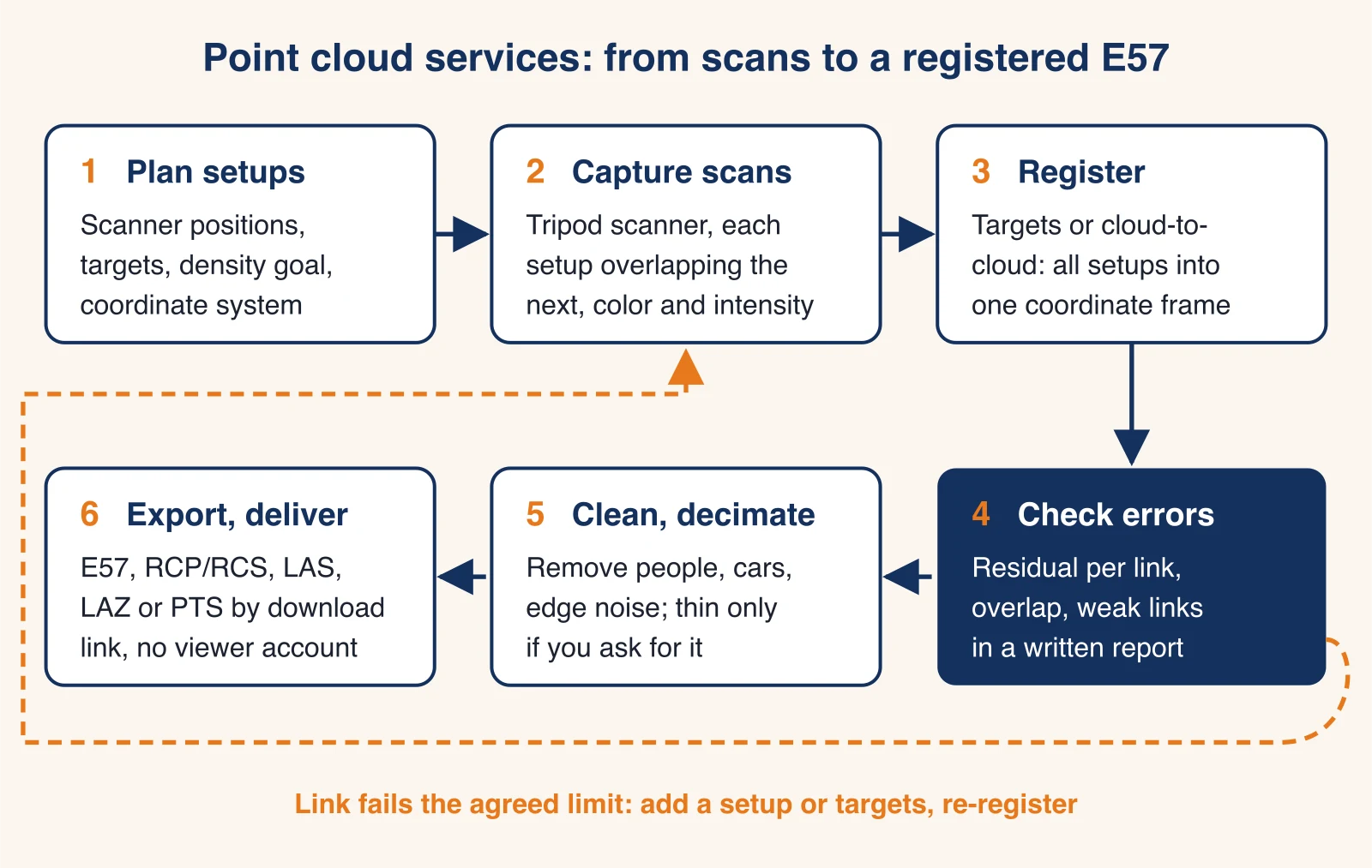
Every registered point cloud we deliver goes through the same six steps. Step 4 is the one that protects you: if a link between scans fails the limit we agreed with you, we fix it before anything is exported.
- Plan the setups. We agree the area, the density goal, the accuracy target, the coordinate system and the formats, then plan scanner positions and, where useful, targets.
- Capture the scans. Each setup overlaps its neighbors so they can be joined. Color photos are taken with the scans when you need a colorized cloud.
- Register. All setups are aligned into one coordinate frame using targets, cloud-to-cloud matching, or both.
- Check the errors. We review the residual error of every link and the overlap between setups, and record them in a registration report.
- Clean and decimate. We remove people, vehicles and edge noise, and thin the cloud only if you ask for a lighter file.
- Export and deliver. We export E57, RCP/RCS, LAS/LAZ or PTS and send a download link, or a drive for very large datasets.
Point cloud registration: targets, cloud-to-cloud and the error report
Registration joins individual scans into one point cloud. Each setup is measured in the scanner's own coordinates, so registration finds the rotation and shift that puts every setup in a common frame. Two methods do this, and most real projects mix them.
Target-based registration
Checkerboard targets or spheres are placed where two or more setups can see them. The software matches the target centers between setups. Targets work well where surfaces are plain or repetitive (long corridors, open turf, empty warehouse floors) and are the usual way to tie a scan to points a surveyor has measured with a total station. They add field time.
Cloud-to-cloud registration
Cloud-to-cloud registration matches the overlapping surfaces of two scans directly, without targets. It is fast in buildings full of walls, columns and ductwork. It struggles where geometry repeats or is flat: a long hallway can slide along itself, and an open field gives the software little to grip. In those places we add targets or extra setups.
Registration error reporting for your Phoenix point cloud
A registered cloud can look clean and still be off by a centimeter or more where two weak links meet. The only way to know is the registration report. Ask any provider for it. We include it with every registered point cloud.
What the registration report lists
The report lists every link between setups, the method used, the overlap, and the residual error after alignment. The example below is illustrative, to show the layout, not data from a real project.
| Link | Method | Overlap | Mean residual | Status |
|---|---|---|---|---|
| Setup 01 to 02 | Cloud-to-cloud | 62% | 1.8 mm | Accepted |
| Setup 02 to 03 | Targets (3) | 38% | 2.4 mm | Accepted |
| Setup 03 to 04 | Cloud-to-cloud | 21% | 7.9 mm | Rejected, setup added |
| Setup 03 to 04b | Cloud-to-cloud + targets | 55% | 2.1 mm | Accepted |
How to read the residuals
The residual is how far matched surfaces or targets still sit apart after alignment. Low residuals with good overlap mean a tight fit. A low residual on a tiny overlap means little, because there was not much to check. The acceptance limit is agreed with you before scanning and follows from your accuracy target.
When a link is rejected
A rejected link is fixed, not hidden: we add a setup or targets, or re-register with constraints, and the report shows the replacement link.
Point cloud accuracy, precision and point spacing
Three numbers get mixed up in point cloud quotes. Keep them apart.
Accuracy vs precision
Accuracy is how close a measured point is to the true position. Precision (or noise) is how tightly repeated measurements of the same flat surface cluster: a wall can be scanned as a band a few millimeters thick. A cloud can be precise and still inaccurate if registration drifted. Our typical accuracy is ±2 to 6 mm at normal working ranges, depending on scanner, range, surface and conditions. That is relative accuracy, inside the cloud.
Point density and point spacing
Point spacing is the distance between neighboring points on a surface. Density says the same thing per area. Spacing decides what you can see in the cloud (a conduit, a crack, a door hinge), not how accurate it is. A cloud with 2 mm spacing is not automatically 2 mm accurate.
How point spacing grows with range
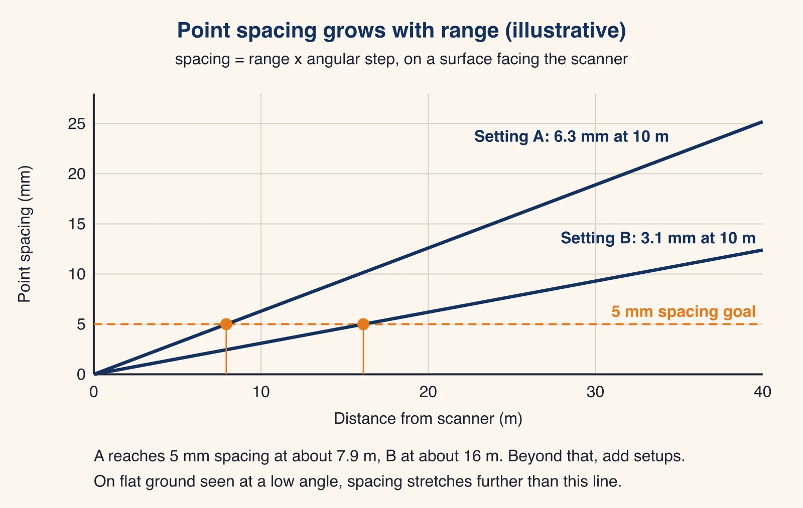
A scanner sweeps its laser at a fixed angular step, so spacing grows in a straight line with distance: spacing = range × angular step. A setting that gives 6.3 mm spacing at 10 m gives about 12.6 mm at 20 m. To hold 5 mm spacing with that setting, the surface must be within about 7.9 m of the scanner (6.3 mm × 7.9 ÷ 10 ≈ 5 mm). On a floor or the ground seen at a low angle, spacing stretches even more in the direction away from the scanner. These figures are illustrative; actual settings depend on the instrument.
Choosing point cloud density by use
Denser is slower and heavier. Pick the density your next step needs:
| What the cloud is for | What must be visible | Density to ask for |
|---|---|---|
| Floor plans, walls, doors (scan to CAD) | Wall faces, openings, ceiling heights | Medium: walls clearly defined, no need for fine detail |
| Revit model, LOD 200 to 300 (scan to BIM) | Walls, slabs, structure, major ducts and pipes | Medium to high in ceilings and plant rooms |
| MEP coordination, tie-ins | Small pipes, hangers, valves, conduit | High, short ranges, extra setups around equipment |
| Flatness, turf or slab surfaces | Small height changes over an area | High on the surface, setups on a tight grid |
| Site context, exteriors, roofs | Massing, edges, rooftop units | Medium; long ranges are fine |
Cleaning and decimating a point cloud
What point cloud cleaning removes
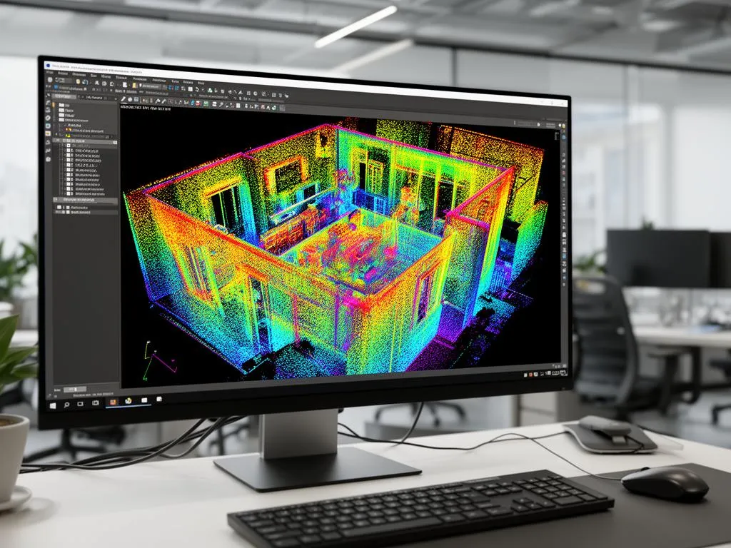
- People and vehicles that moved through the scan, which leave ghost streaks.
- Mixed pixels at edges, where one laser return lands half on a near object and half on a far one and floats in the air between them.
- Reflections from glass, mirrors, polished floors and standing water, which create false geometry behind the surface.
- Sky and far-range noise outdoors, plus anything outside the agreed scope boundary.
Decimation: smaller files, less detail
Decimation (or subsampling) keeps one point per small cell, say every 5 mm or 10 mm. It makes the file far lighter and throws away detail you cannot get back.
When not to decimate
Keep full density for MEP tie-ins, flatness checks and anything you may need to measure later at fine detail. A good compromise: we deliver a decimated working copy and keep a full-density E57 alongside it.
Coordinate systems: local grid or Arizona State Plane
Choose the coordinate system before scanning: changing it later means re-registering.
Local project coordinates
By default a cloud is in a local frame: often the first scanner position or a building grid line set as the origin, with Z up. That is fine for most renovation, scan to CAD and scan to BIM work, where what matters is the building relative to itself. We can align the cloud to your Revit project base point or building grid if you send it.
NAD83 Arizona Central (State Plane)
Site and civil work in Phoenix and the rest of Maricopa County often uses the State Plane system: NAD83 / Arizona Central (EPSG:2223), which state law defines in international feet, not US survey feet. Mixing the two foot definitions or the wrong zone shifts data by a visible amount, so name the system and unit in your request.
Survey control is a surveyor's job
Putting a point cloud on State Plane coordinates to a survey standard requires control points measured by an Arizona-registered land surveyor. We can scan targets that your surveyor has set and measured and register the cloud to them. We do not set or certify survey control ourselves.
Point cloud file formats and the software that opens them
The format decides which software can open your cloud and how big the files are. For a deeper comparison of E57, RCP, LAS and the rest, read our guide to point cloud file formats. Here is the short version.
| Format | What it is | Opens in | Best for |
|---|---|---|---|
| E57 | Vendor-neutral standard (ASTM E2807), compressed, can hold scan positions and images | ReCap, CloudCompare, Leica Cyclone, Trimble RealWorks, most point cloud tools | Archive, hand-off between programs, the default ask |
| RCP / RCS | Autodesk ReCap project (RCP) linking indexed scans (RCS) | Revit, AutoCAD, Civil 3D, Navisworks via ReCap | Teams modeling in Autodesk software |
| LAS / LAZ | Open ASPRS binary format; LAZ is its lossless compressed form | CloudCompare, QGIS, ArcGIS Pro, ReCap | Site, terrain and GIS work |
| PTS | Plain text, one point per line | Almost anything, slowly | Older pipelines that need text |
E57 for a registered point cloud
If you are unsure, ask for a registered E57. It opens almost everywhere, keeps the data in one open format, and can be converted to RCP or LAS later. One project we were asked to quote called for exactly this: a registered point cloud in E57 of part of an outdoor turf field.
RCP and RCS for Revit and AutoCAD
Revit, AutoCAD and Navisworks attach point clouds as ReCap projects. The RCP is a small index file; the RCS files hold the scans. Move them together, folder structure intact, or the links break.
LAS and LAZ for site and GIS work
LAS is the open format of the American Society for Photogrammetry and Remote Sensing, now at version 1.4. Its compressed twin LAZ is typically 7 to 25 percent of the size of the matching LAS file, according to the LAS file format reference.
Point cloud file sizes
Point clouds are big. As an illustrative calculation: 24 setups × 40 million points each = 960 million points. At an assumed 16 to 24 bytes per point with color and intensity, that is about 15 to 23 GB of raw point data before compression. Compression (E57, LAZ, RCS) and agreed decimation bring it down a lot; actual sizes depend on the scanner, settings and how much of each scan is kept.
Point cloud delivery without a subscription viewer
We deliver the files, not a login. You get the registered cloud in the formats you chose, the registration report, and a short readme with the coordinate system, units and scan date, by download link or on a drive for very large datasets. No hosted viewer or subscription is required to keep or open your data: Autodesk ReCap reads E57 and creates RCP/RCS, and CloudCompare is free.
Worked example: a 5 mm point cloud of an outdoor turf field
One request we were asked to quote: a high-density scan of part of an outdoor turf field in Phoenix, a 5 mm accuracy target, and a registered point cloud in E57. The numbers below are illustrative, to show how such a spec turns into a plan. They are not the figures of a real project.
What "5 mm" has to mean in the spec
Before any scanning, a 5 mm target needs one sentence that says which 5 mm:
- Point spacing of 5 mm on the turf surface (what you can see), or
- Relative accuracy of 5 mm between points in the cloud (what you can measure), or
- Absolute position within 5 mm on survey coordinates, which needs surveyed control from a licensed surveyor.
Turf adds its own question: does the surface mean the tips of the fibers or the infill and base below them? The laser mostly hits the fibers. If you need the base, say so, because that changes the method.
Setup plan and point spacing on flat ground
Flat ground is the hard case for point spacing. Seen from a tripod, the turf is hit at a low angle, so points stretch apart in the direction away from the scanner. Illustrative arithmetic: with a scanner head about 1.8 m above the turf and a setting of 3.1 mm at 10 m, a point 5 m away has about 1.55 mm spacing across the line of sight, stretched by roughly 5 ÷ 1.8 ≈ 2.8 times along it, so about 4.3 mm. At 8 m the stretched spacing is about 11 mm. A 30 m × 50 m area on a grid of setups 10 m apart (4 × 6 = 24 setups) keeps every patch of turf within a few meters of several scanners, and targets placed around the area hold registration together where the ground is too flat for cloud-to-cloud matching.
Outdoor point cloud scanning in Phoenix heat
Phoenix summers change how outdoor scans are run. Every scanner has a manufacturer operating temperature range, and an instrument sitting in direct sun on dark turf can reach it. Hot air rising off the surface also bends the laser at longer ranges, which adds noise. We keep ranges short, schedule early starts in the hottest months, and keep monsoon dust and rain in mind when planning field days. More on this in our note on laser scanning in extreme heat.
What gets delivered
Illustrative: the 1,500 m² area thinned to one point per 5 mm cell is 1,500 ÷ (0.005 × 0.005) = 60 million points for the turf surface, roughly 1 to 1.5 GB at the same assumed 16 to 24 bytes per point. The delivery would be a registered E57 (full density and 5 mm thinned), the registration report, and the coordinate note. A surface model or flatness map is a separate deliverable you can add.
What you can build from a Phoenix point cloud
The point cloud is usually the start of the work, not the end. When your team does not want to model from it in-house, we can:
- Build a Revit model from it: see scan to BIM in Phoenix.
- Draw 2D floor plans, elevations and sections in DWG: see scan to CAD in Phoenix.
- Scan large outdoor sites and structures: see LiDAR scanning in Phoenix.
Point cloud services in Scottsdale and across the Valley
We provide point cloud services in Scottsdale, Tempe, Mesa, Chandler, Glendale, Gilbert, Peoria, Surprise and Avondale, as well as Phoenix itself. Projects we are asked to quote in Scottsdale include multi-building commercial sites in Old Town and multi-story office buildings; see our page on 3D laser scanning in Scottsdale. Prescott, Flagstaff and Tucson are case by case, and projects outside the immediate Phoenix area may include travel time.
Turnaround and price drivers for point cloud services in Phoenix
Turnaround
We typically reply to quote requests within one business day. Typical commercial scanning takes 1 to 3 days on site, and processing takes 3 to 10 business days depending on size and deliverables. Rush delivery may be available at premium pricing, and after-hours or weekend scanning may be available at premium rates for occupied buildings and operating businesses.
What drives the price of a point cloud
Most commercial scanning projects in Phoenix range from $2,500 to $15,000. Where your project lands depends on:
| Driver | Why it moves the price |
|---|---|
| Area and number of rooms or levels | More setups and more field time |
| Density and accuracy target | Shorter ranges mean more setups; targets add field time |
| Color | Photos at every setup add time on site |
| Access and safety | Roofs, lifts, occupied spaces, escorts, after-hours work |
| Coordinate system | Registering to surveyor control adds coordination and checks |
| Formats and splits | Several formats, or a cloud split by level or area, add processing |
| Timeline and travel | Rush delivery and sites outside the Phoenix area cost more |
What to send for a point cloud quote
Send these and you will get a firm, detailed quote, usually within one business day:
- Address, and the area to scan (sq ft, or a marked-up site plan or aerial).
- Interior, exterior, roof, or open site; occupied or not; any access limits.
- What the cloud is for (floor plans, BIM, MEP, flatness, record).
- Accuracy target and density, if you have them, and what they mean (see the 5 mm example above).
- Formats (E57, RCP/RCS, LAS/LAZ, PTS), color or not, and coordinate system and units.
- Deadline and the earliest date the site is available.
Request a point cloud quote or call (520) 800-5310. If you only need part of the job, for example a registered E57 your own team will model, tell us the scope and we will price just that.
Frequently asked questions
What is a registered point cloud?
A registered point cloud is the result of aligning every individual scan of a site into one shared coordinate system, so a wall seen from five scanner positions appears once, in one place. Registration is done with targets, with cloud-to-cloud matching of overlapping surfaces, or both. Ask for the registration report: it shows how well each pair of scans fits.
Which file format should I ask for: E57 or RCP?
Ask for E57 if the data must open in several programs or be archived: it is the vendor-neutral ASTM format. Ask for RCP/RCS if your team works in Revit, AutoCAD or Navisworks, which attach ReCap projects directly. Many clients take both, and we can deliver both from the same registration.
How accurate are your point clouds?
Typical accuracy is ±2 to 6 mm at normal working ranges, depending on the scanner, range, surface and conditions. That is relative accuracy inside the point cloud. Positioning the cloud on survey coordinates to a certified standard is the job of an Arizona-registered land surveyor, and our deliverables are non-certified.
How big are point cloud files?
Large. A full-density registered cloud of one commercial building often runs to tens of gigabytes. Compressed formats (E57, LAZ, RCS) and agreed decimation bring that down a lot. We send files by download link, or on a drive when the dataset is too big to transfer comfortably.
Do I need special software or a subscription to open the point cloud?
No subscription is needed. Autodesk ReCap opens E57 and creates RCP/RCS; CloudCompare is free and opens E57, LAS and PTS. We hand over the files themselves, not a hosted viewer link, so you keep the data.
How long do point cloud services take in Phoenix?
Typical commercial scanning takes 1 to 3 days on site, and processing takes 3 to 10 business days, depending on size and the deliverables. Rush delivery may be available at premium pricing. We reply to quote requests within one business day.
How much do point cloud services cost?
Most commercial scanning projects in Phoenix range from $2,500 to $15,000, depending on area, density, accuracy target, access, formats and timeline. A point cloud on its own costs less than the same scan modeled into Revit or drawn in CAD. You get a detailed quote before any work starts.
Do you offer point cloud services in Scottsdale?
Yes. We scan across the Phoenix metro and Maricopa County, including Scottsdale, Tempe, Mesa, Chandler and Glendale. Projects outside the immediate Phoenix area may include travel time in the quote.